MYSUSÆTER · RONDANE · NORWAY

Explore Rondane.
From your cabin doorstep.

Gentle walks, towering summits and river adventures. These are our favourite experiences for guests staying at Berget or Granheim.

YOUR MOUNTAIN BASE

Head outside.
Come home to comfort.

From Mysusæter you can embark on beautiful walks without getting into a car. Enjoy an easy viewpoint stroll, discover the Ula waterfalls or spend the entire day in the mountains.

We have put together local route suggestions with practical details. Distances refer to the described starting points in Mysusæter; walks directly from your cabin may be slightly longer or shorter.

01 · WALKS FROM MYSUSÆTER

Seven walks from the cabin

From short viewpoint trips to longer loops through woodland and beside the river – all can be started near our cabins in Mysusæter.

7 WALKING ROUTES
01
4.5 kmMarked paths

Bergetjønn circular walk

A lovely loop beside Bergetjønn, with views of Rondane and the chance to swim on the north shore of the lake.

Read the route description

Follow Tjønnbakkvegen uphill. At the top of Tjønnbakken, take the green-marked path to the left and continue along Bergetjønn. Walk through birch woodland and follow the blue-marked road back to Mysusæter.

Highlight: Views of Rondane and swimming by Bergetjønn.
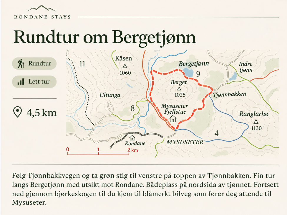
Bergetjønn circular walk – route map
Circular walk from Mysusæter via Tjønnbakken and Bergetjønn.Open full map ↗
02
approx. 4 kmRed-marked trail and road

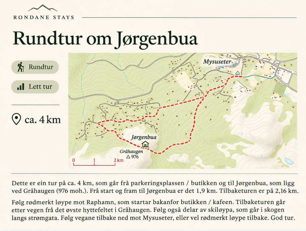
Jørgenbua circular walk

A varied woodland and mountain-farm walk to Jørgenbua by Gråhaugen (976 m).

Read the route description

Start at the shop in Mysusæter and follow the red-marked route towards Raphamn, behind the shop/café. Jørgenbua is around 1.9 km away. On your return, follow the roads from the upper cabin area by Gråhaugen and a section of the ski trail through the woodland alongside the power line. Alternatively, return on the red-marked path.

Highlight: Jørgenbua and the wooded terrain around Gråhaugen.

Jørgenbua circular walk – route map
A loop from the Mysusæter shop to Jørgenbua.Open full map ↗
03
6 kmBlue-marked

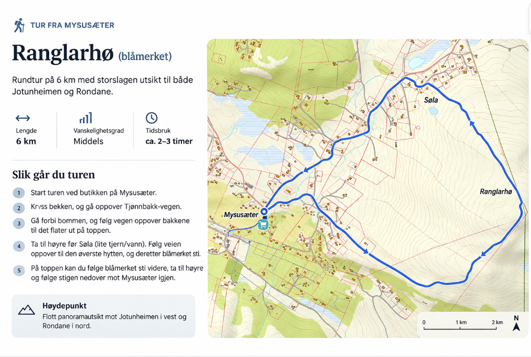
Ranglarhø

A beautiful circular hike with wide views of Jotunheimen and Rondane.

Read the route description

Start at the shop, cross the stream and take Tjønnbakkvegen uphill past the barrier. Where the road levels out, turn right before the small lake Søla. Continue to the uppermost cabin and follow the blue-marked path towards the summit. The marked route descends towards Mysusæter.

Highlight: Panoramic views of Rondane and Jotunheimen.

Ranglarhø – route map
Blue-marked circular walk over Ranglarhø.Open full map ↗
04
4.5 kmBlue- and green-marked

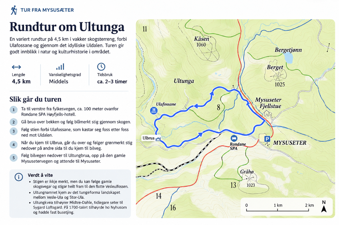
Ultunga circular walk

A scenic route through birch woodland, along the Ula river and past several waterfalls.

Read the route description

Turn left off the county road about 100 metres above Rondane SPA. Cross the stream by the bridge and follow the blue-marked path through the woods beside Ulafossene. Cross Ulbrua and follow the green-marked trail to the road. Return via Ultungbrua and the old Mysusetervegen.

Highlight: Ulafossene waterfalls and views into Uldalen.

Good to know: The additional path towards Vesleulfossen is unmarked and should not be confused with the main circular route.

Ultunga circular walk – route map
A loop via Ultunga, Ulbrua and the old Mysusetervegen.Open full map ↗
05
2.16 kmGreen-marked

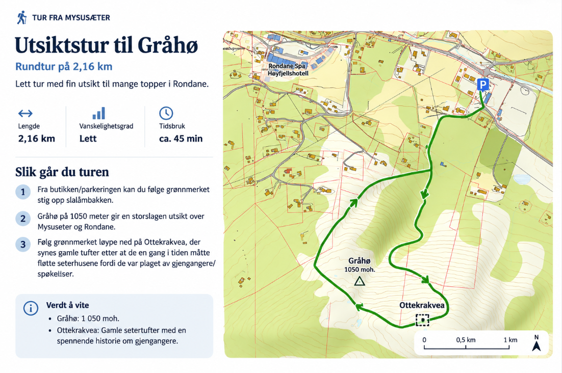
Gråhø viewpoint walk

A short, easy loop to Gråhø (1,050 m), overlooking Mysusæter and the Rondane mountains.

Read the route description

From the shop/parking area follow the green-marked route up the ski slope. Continue to Gråhø, then follow the green route down via Ottekrakvea and back to the start.

Highlight: Impressive views for a relatively short walk.

Good to know: Near Ottekrakvea you can see traces of an old mountain farm and hear local stories about ghosts.

Gråhø viewpoint walk – route map
Green-marked loop from Mysusæter via Gråhø.Open full map ↗
06
2.5–11 kmBlue-marked

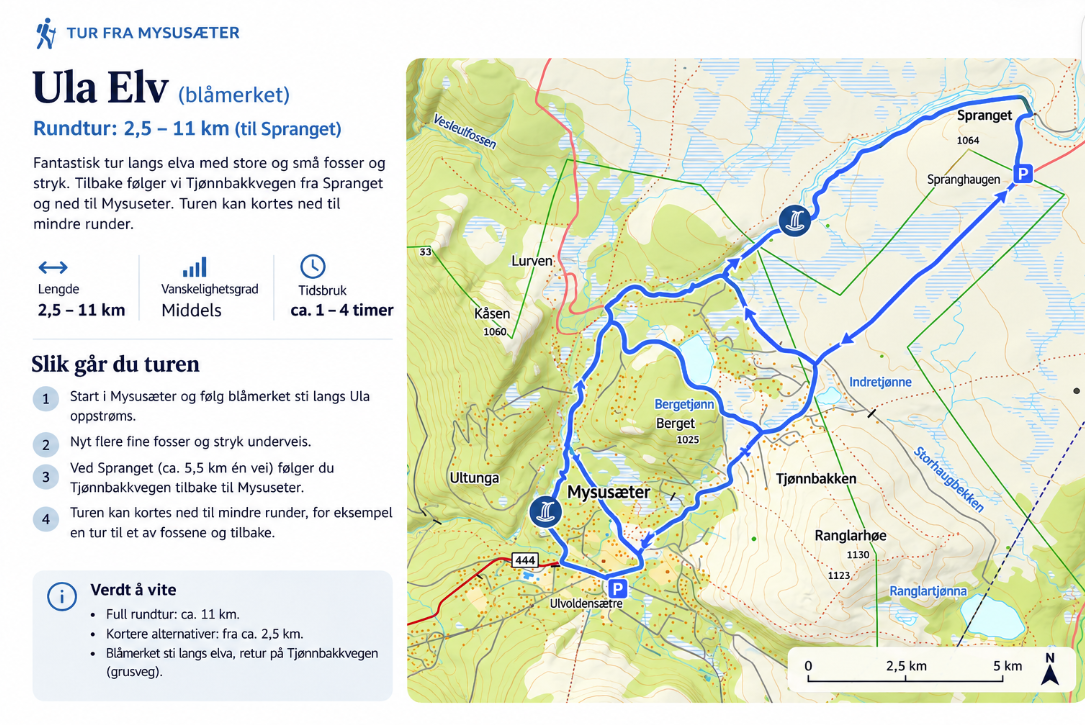
Along the Ula river to Spranget

Follow the beautiful Ula river past rapids and waterfalls. Choose a shorter walk or complete the longer loop via Spranget.

Read the route description

Follow the blue-marked trail upstream along the Ula from Mysusæter. You will pass several waterfalls. For the longer version, continue towards Spranget and return to Mysusæter via Tjønnbakkvegen. Shorter loops are possible.

Highlight: River landscapes, waterfalls and flexible route lengths.

Good to know: Distances depend on the loop you choose. Check maps and local conditions before setting out.

Along the Ula river to Spranget – route map
Short and long loops along the Ula, with an option to continue to Spranget.Open full map ↗
07
approx. 2.5 kmYellow- and blue-marked

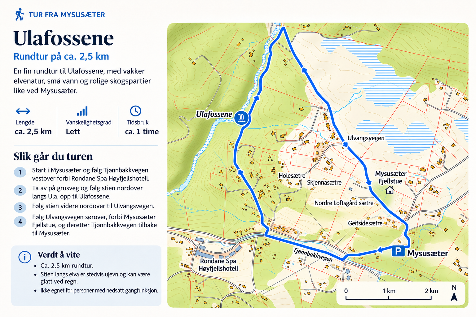
Ulafossene waterfalls at Mysusæter

A short but rewarding circular walk to the Ula rapids and waterfalls, around 20–25 minutes’ walk from the parking area.

Read the route description

Follow the road towards Rondane SPA and cross the stream using the bridge by the electric cattle grid. Follow the path along the river to the bridge over the Ula. Cross the bridge, then return via Ulvangsvegen, Mysusæter Fjellstue and Tjønnbakkvegen.

Highlight: The Ulafossene waterfalls and rushing river.

Good to know: The path is uneven and may be slippery, especially after rain. It is not well suited to people with limited mobility.

Ulafossene waterfalls at Mysusæter – route map
Circular walk alongside Ulafossene returning via Ulvangsvegen.Open full map ↗

These walks follow marked trails, roads and some unmarked detours. Always check updated maps, weather and trail conditions. These descriptions offer inspiration and should not be relied upon for navigation.

02 · INTO THE HIGH MOUNTAINS

Mountain hikes and 2,000-metre summits

Fancy climbing higher? Rondane has some of Norway’s finest summit walks. Veslesmeden and Storronden are excellent choices for experienced hikers.

FEATURED SUMMIT↗

Veslesmeden

2,015 m

One of Rondane’s most approachable 2,000-metre summits, with spectacular views of Rondslottet, Vinjeronden and Storronden.

A summit hike from Rondvassbu. Requires mountain experience, suitable weather and proper equipment.

See trail details at DNT / UT.no ↗
FEATURED SUMMIT↗

Storronden

2,138 m

A classic summit hike with a steep climb, rocky scree and sweeping views across Rondane.

From Rondvassbu. Exposed in strong winds and poor weather; take particular care near the cliff edge at the summit.

See trail details at DNT / UT.no ↗
HIGH MOUNTAIN HIKE↗

Vinjeronden

2,044 m

A striking viewpoint on the route to Rondslottet, with increasingly steep, rocky ground at higher elevations.

From Rondvassbu. A demanding mountain hike best attempted in good conditions.

See trail details at DNT / UT.no ↗
HIGH MOUNTAIN HIKE↗

Rondslottet

2,178 m

The highest summit in Rondane. A long, demanding hike over rugged mountain terrain and scree, via Vinjeronden.

From Rondvassbu. Allow plenty of time and assess the weather, visibility and your experience.

See trail details at DNT / UT.no ↗
Before you set off

Rondvassbu is a common starting point for these summit hikes, and the walk there is additional. High mountain hikes require careful planning, proper equipment and experience, as well as a responsible assessment of weather, visibility and conditions. Check current access to Spranget and Rondvassbu before travelling.

More summit inspiration: Rondane og Dovre nasjonalparker ↗.

03 · WINTER IN RONDANE

Cross-country skiing, backcountry skiing and ski touring

Spend winter in Mysusæter surrounded by beautiful Norwegian mountain scenery. Enjoy kilometres of groomed cross-country ski trails through forests and open terrain, or discover the mountains beyond the tracks on backcountry skis.

01

Groomed cross-country ski trails

More than 100 kilometres of trails are normally groomed in the Mysusæter area during the season when snow conditions allow. Choose gentle outings or longer ski days. Check the latest trail grooming status before setting off.

02

Backcountry skiing on fjellski

Norwegian mountain skis (fjellski) open up quiet winter landscapes around Rondane. Follow marked or winter-waymarked routes where available and plan carefully for the weather, visibility and snow conditions.

03

Ski touring and randonee

Experienced ski tourers can find possibilities for mountain ascents and ski touring around Rondane. Avalanche assessment, appropriate rescue equipment and local knowledge are essential. Not every summit or route is suitable for a ski descent.

Always check the weather forecast, avalanche bulletins and local access guidance before heading into the mountains. Respect the wild reindeer habitat in Rondane. Trail grooming, winter route marking and access depend on conditions.

Berget and Granheim are excellent bases for a skiing holiday in Mysusæter. Return to a cosy Norwegian cabin after a full day outdoors.

Explore our ski holiday cabins ↗
04 · ADVENTURES WITH ADRENALINE

Rafting in Sjoa

A mountain holiday does not have to mean hiking every day. Rafting on the Sjoa river is an exciting way to experience a different side of the region.

Explore the river and rapids with experienced guides. Explore Sjoa offers family-friendly rafting and more challenging adventures, as well as via ferrata, canyoning, climbing and riverboarding.

Choose a trip suited to your age and experience, and check the season, safety requirements and availability directly with the operator.

Explore rafting with Explore Sjoa ↗

Activities are operated by independent providers and booked directly with them.

River adventures and unforgettable scenery in Sjoa Photo coming soon
STAY IN RONDANE

Every adventure needs
a place to come home to.

Explore the mountains by day, then settle into your cosy cabin in the evening. Discover our two cabins in Mysusæter and find dates that suit you.

Meet Berget and Granheim ↗